
The Blog

Harpea Cave from the Spanish Side: The Wild Route Through Irati Forest
Most people visit Harpea Cave from France. And honestly, after doing it from the Spanish side, I completely understand why.
From the French side, there are several established routes to the cave. There’s even a beautiful 14km circuit featured on AllTrails. But there’s also a much easier option where you simply park near the cave, walk around 3km along a road with beautiful mountain views, and then follow a short section of single track for about 15 minutes to reach Harpea itself.
Easy. Straightforward. Predictable.
We did not choose that option.
Instead, after exploring the Real Fábrica de Armas y Municiones de Orbaizeta and spending time in the Selva de Irati, we decided to approach the cave from the Spanish side.
A decision the man at the Irati access gate very politely suggested we reconsider. He recommended the French side but not wanting to drive all the way around, we continued regardless thinking, how challenging could it be?
Now that I have done it, I completely understand his advice, but I’m also very glad we ignored it. Because this wasn’t just a hike to a cave. It felt like an adventure.
Disclaimer! All of my blogs may contain affiliate links. This means that if you click on the link and make a purchase I may receive a small amount of commission for the referral at no extra cost to you. This commission is what allows me to continue creating guides to help travellers plan their next trip!
What's in this post:
Harpea Cave from the Spanish Side: The Wild Route Through Irati Forest
Important Information Before You Start
This route is:
- completely unmarked,
- physically demanding,
- and requires navigational awareness.
This is not the standard easy Harpea walk you’ll see online.
Hike Details
| Detail | Information |
|---|---|
| Distance | 8.1km |
| Elevation Gain | 532m |
| Difficulty | Hard |
| Route Type | Completely unmarked |
| Best For | Experienced hikers comfortable navigating terrain |
| Not Suitable For | Beginners or anyone expecting a marked trail |
You should ideally:
- carry a GPX route,
- feel comfortable navigating independently,
- wear proper hiking boots,
- and avoid this route in poor visibility.
Getting to the Start Point
To access the route, you first need to drive into the “Irati entrance “Punto de informacion de Irati” and pay the €7 day access fee.
From there, continue driving to the second parking area near the trail start. Ckick here is the exact Google location.
The First Section: Easy Walking and Horses
The hike begins pleasantly enough along a steadily climbing farmer’s track.
The path is stony and gravelly but straightforward, winding uphill through rolling green mountain pasture.
This is where we saw huge Percheron-style horses (meat horses commonly raised in the area) including several foals sleeping peacefully in the grass. One was so deeply asleep on our return journey that it didn’t even wake up as we walked past.
Buzzards and kites circled overhead. Wildflowers covered the hillsides.
And although much of this route isn’t actually inside the forest, you spend much of the climb looking over the vast expanse of Irati below. And from above, I finally understood why it’s called the Selva de Irati rather than simply the Bosque de Irati.
“Forest” somehow feels too neat a word.
From the surrounding slopes, Irati looks immense. Dense. Continuous. More like a green ocean swallowing entire valleys than a collection of trees.

Where the Trail Ends
Eventually you reach a couple of abandoned farm buildings which is where the actual trail effectively ends.
From here onwards, there is no marked route whatsoever.
There are plenty of animal tracks, and initially they feel reassuring. Naturally, you start following them because walking on flattened ground is easier than scrambling through uneven vegetation.
But remember: they are animal tracks, not hiking trails.
Sometimes they head exactly where you need to go. Sometimes they very much do not. You still need to remain aware of your surroundings at all times.

Your goal is the col above.
Eventually, after traversing the hillside and choosing your own route upwards, you’ll spot the obvious line towards it.
Because there’s no defined trail, you may find yourself tempted to simply attack the slope directly upwards. You can do that. Your legs may not thank you for it.
Zigzagging is kinder.
Either way, eventually you’ll reach the col and a very important landmark: a signpost marking several GR routes.
Important. You are not following any of those GR trails.
But this signpost is crucial because:
- it marks the beginning of the valley descent,
- and later becomes your key navigation point on the return journey.
As long as visibility is good, navigation is actually surprisingly manageable because you always have strong landscape markers:
- the opposite road cut into the mountainside,
- the col,
- and the valley itself.

Descending into the Valley
Slightly left of the GR signpost, you’ll notice several wooden hunting shelters.
This marks the beginning of your descent.
From here, the objective is simple in theory: follow the stream cutting through the valley until you eventually reach Harpea Cave.
In practice, it’s rather more chaotic. We chose to descend through the forest itself. And honestly, it was beautiful.
This isn’t technically virgin forest, but it feels wonderfully untouched. Trees are allowed to fall, decay, and decompose naturally. Massive bracket fungi the size of doorstops grow from rotting trunks. Moss covers everything. The forest floor feels alive.
But navigating through it is slow. Very slow.
You constantly think: “Ah yes, this is fine.” before suddenly finding yourself in what appears to be a dead end with steep terrain dropping away on both sides.

The important thing to remember is that the cave is beside the stream at the bottom of the valley.
As long as you are gradually descending, you’re broadly heading in the right direction.
Still, this is not fast hiking.
I suspect the route took us considerably longer than the mileage would normally suggest simply because we weren’t able to move automatically in the way you do on a marked trail. Every section required thought:
- choosing lines,
- checking footing,
- deciding whether to stay in the forest or move out into the open,
- constantly reassessing terrain.
Oddly, that’s also part of what made this route feel so immersive. You cannot switch your brain off here. You are fully present the entire time.
Reaching Harpea Cave

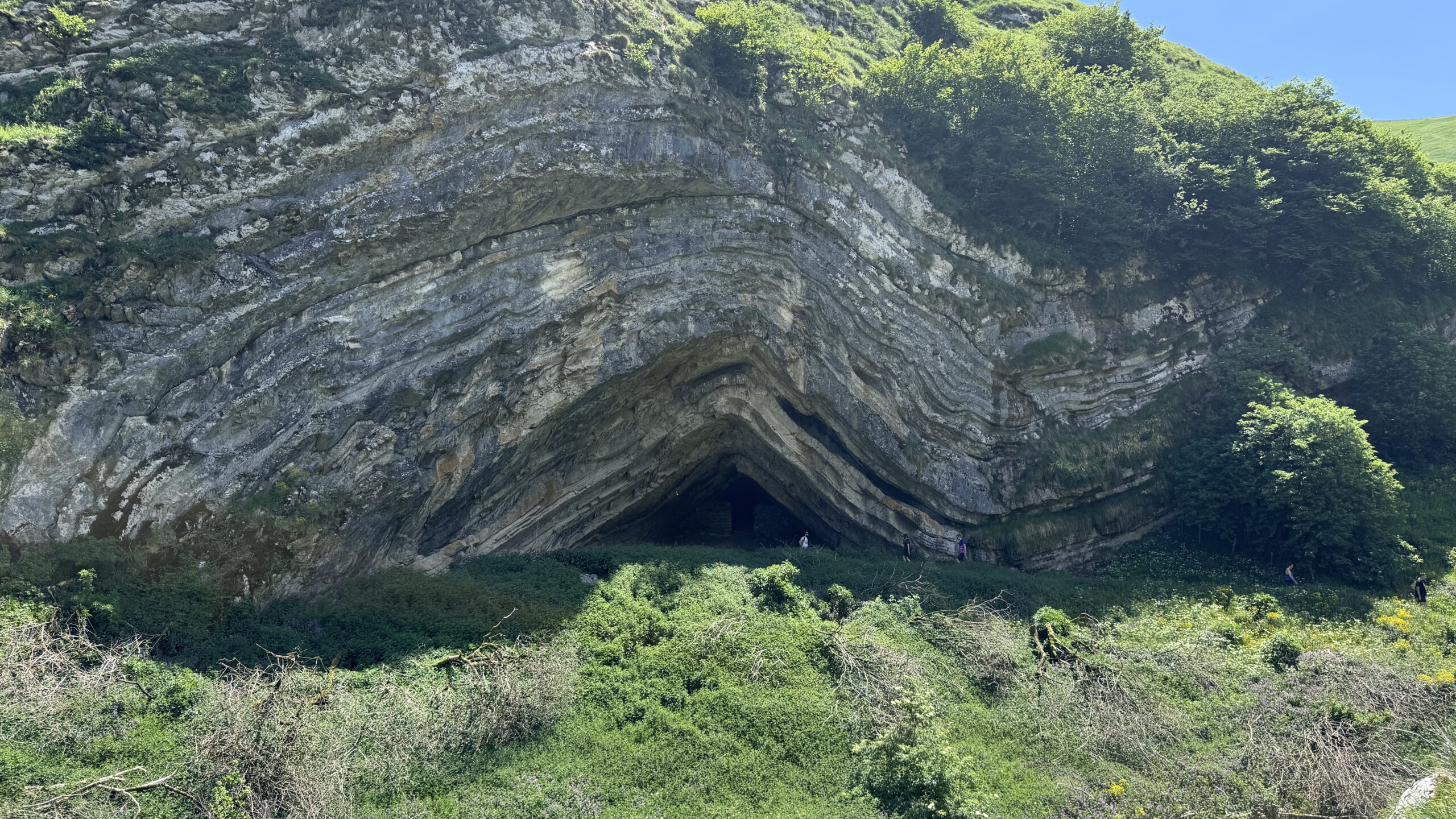
Eventually, we emerged from the forest for one final steep grassy descent, that lead to a tiny wooden bridge, an old abandoned stone shepherd’s hut, and finally the cave itself.
Although “cave” perhaps isn’t entirely accurate.
Harpea is more like a gigantic fold in the mountain, an enormous geological crease carved into the cliffs.
And the rock formation is phenomenal. The layers curve and bend dramatically above the entrance in a way that almost looks unnatural, as though the mountain itself has been twisted.
It is immediately obvious why mythology became attached to this place.
According to Basque folklore, caves like this were associated with the lamiak, mysterious female beings said to inhabit rivers, caves, forests and springs throughout the Basque Country.
Descriptions vary depending on the region, but they are often portrayed as beautiful women with animal features such as duck feet, bird claws, or goat-like legs. Stories describe them combing their hair beside streams with golden combs, seducing travellers, helping humans, tricking humans, and gradually retreating deeper into the wilderness as Christianity spread across the mountains.

One tip:
Don’t just stop at the cave entrance itself. Walk a little further along the path beyond it because that’s where some of the best overall views of the rock formation reveal themselves.
We sat there eating lunch beside the stream, staring up at the folded cliff face and wondering what geological event had happened to create Harpea Cave.
The Return Journey: Brutal but Easier to Navigate
Leaving the cave felt considerably more daunting than reaching it. We now we had to regain all the elevation we had just lost.
And it is steep. Very steep.
We also decided we didn’t particularly fancy navigating back uphill through dense forest, especially in the heat, so instead we chose to gain elevation quickly before following the outer edge of the woodland.
This was physically far more brutal. But navigationally much easier.
We tried to remain close enough to the forest to benefit from occasional shade without fully re-entering the trees and slowing ourselves down again.

The climb out genuinely felt harder than the statistics suggest. Physically, this hike isn’t especially long. But uneven terrain is tiring in a completely different way to normal trail hiking. Your stabilising muscles are constantly working, your footing is inconsistent, and you never quite settle into an easy rhythm.
Eventually, after a great deal of sweating and self-negotiation, we reached a wonderful cold-water trough where we completely soaked our heads before tackling the final ascent back to the col.
From there:
- locate the GR signpost,
- descend diagonally to save your knees,
- and gradually reconnect with the animal tracks leading back towards the farm track.
Tick Warning: Take This Seriously
One very important thing worth mentioning: ticks.
There were a lot of them. I removed more than ten. Most are tiny little black dots when they first attach themselves and are very easy to mistake for dirt.
They are not dirt.
Wear:
- long trousers if possible,
- tick repellent,
- and thoroughly check yourself afterwards.
This route involves moving through long grass, rough vegetation and forest for extended periods.

Is the Spanish-Side Route Worth It?
Honestly?
That depends entirely on what you want from the experience.
If your goal is simply to see Harpea Cave, then the French side is undeniably easier, quicker and more accessible.
But if you enjoy:
- route-finding,
- mountain solitude,
- slightly chaotic adventures,
- untamed-feeling landscapes,
- and hikes that demand your full attention,
then the Spanish-side approach offers something very different.
This is not the easiest route to Harpea.
But it might just be the most memorable.
")
Comments will load here
Be the first to comment